Getxophoto se reinicia en su 20 aniversario
El Getxophoto celebrará su nueva edición del 28 de mayo al 21 de junio de 2026, convirtiendo una vez más Getxo en un espacio de encuentro para la fotografía contemporánea y la cultura visual

Jokin Aspuru, director de Getxophoto
El código iframe se ha copiado en el portapapeles
Durante varias semanas, Getxophoto transformará calles, plazas y espacios urbanos en una gran galería al aire libre, invitando al público a descubrir proyectos de artistas internacionales que utilizan la imagen como herramienta para explorar el mundo que nos rodea.


Bangladesh is the scapegoat of global warming, with the Sundarbans inhabitants seeking global attention. The Sundarbans, the world's largest mangrove forest, spans 140,000 hectares across the delta formed by the Ganges, Brahmaputra, and Meghna Rivers. Mostly in Bangladesh, with parts in India, it’s a UNESCO World Heritage site since 1987. This ecological marvel in the Bay of Bengal hosts 260 bird species, the Royal Bengal Tiger, and endangered species like the estuarine crocodile and Indian python. Climate change also affects agriculture, leading to food insecurity. Women, especially pregnant and breastfeeding mothers, face malnutrition and related health issues. Using biomass fuels for cooking in poorly ventilated spaces, combined with saline air, increases respiratory infections and chronic conditions. Saline drinking water links to higher hypertension rates, risking cardiovascular diseases. An integrated approach is needed for clean water, healthcare, nutrition, and education. Projections show the Sundarbans could be 70% submerged by 2100, exacerbating land loss and causing mass exodus. / Mohammad Rakibul Hasan


Four fishermen's families brought their remaining storage of food to the table. They are locals of an island adjacent to the Sundarbans Forest in Bangladesh, where they live in harsh conditions. The river constantly erodes lands, cyclones are an annual affair, and relocation is repeated. On the other hand, climate change and the impact of the coronavirus pandemic are nibbling away at whatever peace they had left. Bangladesh, the world's largest delta, is a direct victim of global warming. Increased natural disasters like cyclones and oceanic tidal waves affect Bangladesh's coastal area. The coastal lowlands of this country have millions who, ironically, depend on the sea for their livelihood. Bangladesh's low-lying coastal areas are speculated to be submerged due to sea-level rise as the world temperature increases. Immediate natural calamities like cyclones and tidal floods worsen the situation. As rising sea levels and unusually high tidal waves encroach upon the lowlands of Bangladesh, the coastal areas face increased salinity. When the upstream water flows reduce drastically in the dry season, the saline water goes up to 240 kilometers inside the country and reaches distant regions. This has meant that agricultural activities and cropping strength have changed; farmers cannot grow various crops yearly. Food and work opportunities are getting reduced. Another factor that helps the continuous proliferation of salinity on the mainland is shrimp cultivation, which involves trapping seawater in agricultural lands for a long time. Fig can grow faster in saline areas. Around coastal regions of Sundarbans, the increase of fig trees is a sign of an alarm that the other species that cannot adapt to the salinity may disappear. / Mohammad Rakibul Hasan


Bangladesh is the scapegoat of global warming, with the Sundarbans inhabitants seeking global attention. The Sundarbans, the world's largest mangrove forest, spans 140,000 hectares across the delta formed by the Ganges, Brahmaputra, and Meghna Rivers. Mostly in Bangladesh, with parts in India, it’s a UNESCO World Heritage site since 1987. This ecological marvel in the Bay of Bengal hosts 260 bird species, the Royal Bengal Tiger, and endangered species like the estuarine crocodile and Indian python. Climate change also affects agriculture, leading to food insecurity. Women, especially pregnant and breastfeeding mothers, face malnutrition and related health issues. Using biomass fuels for cooking in poorly ventilated spaces, combined with saline air, increases respiratory infections and chronic conditions. Saline drinking water links to higher hypertension rates, risking cardiovascular diseases. An integrated approach is needed for clean water, healthcare, nutrition, and education. Projections show the Sundarbans could be 70% submerged by 2100, exacerbating land loss and causing mass exodus. / Mohammad Rakibul Hasan
Four fishermen's families brought their remaining storage of food to the table. They are locals of an island adjacent to the Sundarbans Forest in Bangladesh, where they live in harsh conditions. The river constantly erodes lands, cyclones are an annual affair, and relocation is repeated. On the other hand, climate change and the impact of the coronavirus pandemic are nibbling away at whatever peace they had left. Bangladesh, the world's largest delta, is a direct victim of global warming. Increased natural disasters like cyclones and oceanic tidal waves affect Bangladesh's coastal area. The coastal lowlands of this country have millions who, ironically, depend on the sea for their livelihood. Bangladesh's low-lying coastal areas are speculated to be submerged due to sea-level rise as the world temperature increases. Immediate natural calamities like cyclones and tidal floods worsen the situation. As rising sea levels and unusually high tidal waves encroach upon the lowlands of Bangladesh, the coastal areas face increased salinity. When the upstream water flows reduce drastically in the dry season, the saline water goes up to 240 kilometers inside the country and reaches distant regions. This has meant that agricultural activities and cropping strength have changed; farmers cannot grow various crops yearly. Food and work opportunities are getting reduced. Another factor that helps the continuous proliferation of salinity on the mainland is shrimp cultivation, which involves trapping seawater in agricultural lands for a long time. Fig can grow faster in saline areas. Around coastal regions of Sundarbans, the increase of fig trees is a sign of an alarm that the other species that cannot adapt to the salinity may disappear. / Mohammad Rakibul Hasan
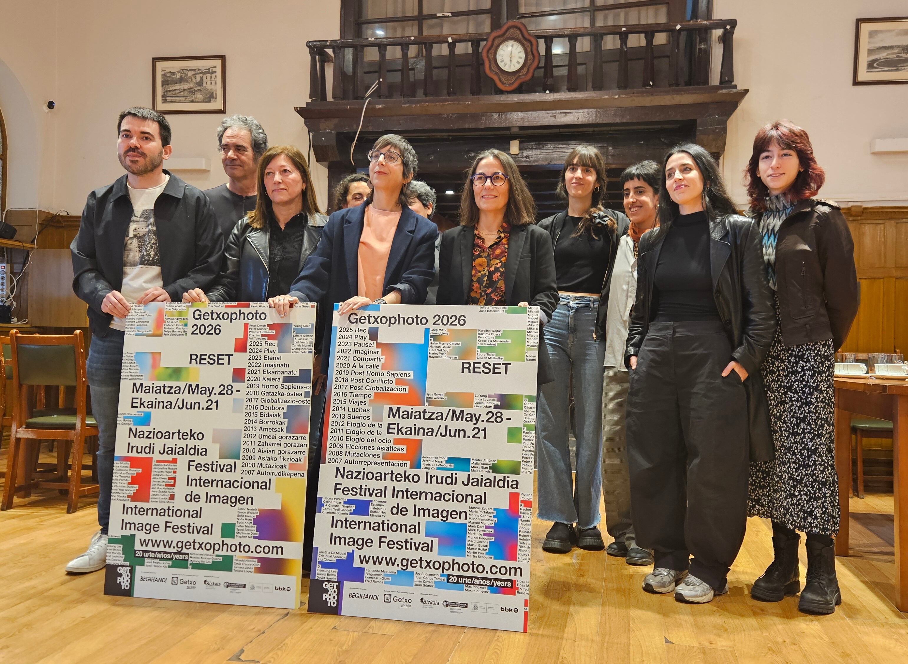
A la presentación han asistido la alcaldesa de Getxo, Amaia Agirre, Ana López, directora de Promoción Cultural del Gobierno Vasco, Jokin Aspuru, director de Getxophoto y María Ptqk, comisaria de la exposición.

Presentación del cartel de Getxophoto 2026 / Juan Carlos Otaola
Presentación del cartel de Getxophoto 2026 / Juan Carlos Otaola
RESET: el tema de la edición 2026
En junio de 2026 Getxophoto cumple 20 años, y lo hace bajo el concepto RESET, un tema que invita a detenerse, replantear y reiniciar. Tras las tres ediciones anteriores dedicadas a PAUSA, PLAY y REC, la próxima edición propone pulsar la tecla que permite reiniciar el sistema.
El festival acogerá proyectos que exploran experiencias de cambio, reciclaje, reinvención y transformación, así como relatos sobre ciclos vitales, celebraciones o historias individuales y colectivas de reseteo. Una invitación a reflexionar sobre cómo las personas y las sociedades se adaptan, evolucionan y encuentran nuevas formas de comenzar de nuevo.

Descubre la nueva app de Cadena SER Te ofrecemos una mejor experiencia de audio y video
Descargar
Arte, fotografía y espacio público
Una de las señas de identidad de Getxophoto es su relación con el espacio urbano. Muchas de las exposiciones se presentan al aire libre o en lugares inesperados del municipio, permitiendo descubrir las obras mientras se recorren calles y plazas.
Este diálogo entre fotografía, ciudad y ciudadanía convierte cada edición del festival en una experiencia cultural única que acerca el arte contemporáneo a todos los públicos.


